AI for pilots and dispatchers

What can AI do for aviation?

AQ is Aeronautic's working answer to two practical questions: what can AI do for us in aviation, and just how far can a small team run when it leverages agentic engineering? It is where we build helpful utilities and AI operations agents for pilots, dispatchers, and operators. We started by filling gaps we felt directly: a customs finder, a door-to-door planning assistant, a multi-city planner, route lookup, wind lookup, and airport maps with FBO-chain and fuel-program filters. Now we are using ontological neural network technology to build smarter procedure charts and keep exploring what else AI can make useful.

Procedures first Airports next Planner connected
AI Creates Smarter Procedures

Smarter Procedures

The future of charts is data-driven. The chart as we know it is a precomposed graphic; it will gradually give way to interactive depictions that change with the flight you are planning. With 1A1's ontological neural network technology, we process raw FAA procedure definitions from the 8260 family of documents into deterministic chart models: no hallucinated facts, the same answer every time, and only the information you need for the aircraft, transition, and conditions in front of you. This can start on computers, but it points toward a future where data-driven procedure charts can exist across avionics platforms, not just web screens.

  • Transitions Select a feeder or IAF and the plan view shows the path from that transition into the approach segment while the vertical profile updates to match.
  • Minima Show the minima that apply to your aircraft category and operating conditions, including cases like a remote altimeter setting.
  • 3D View Pan, tilt, and zoom through terrain-aware procedure geometry to understand vertical context, missed routing, and path relationships.
  • Fly-through Fly the approach inside the plan view and watch the procedure depiction, selected path, and profile work together instead of staying frozen on a static plate.
aeronautic.ai / procedures RNAV (GPS) RWY 08
Transition path
Via BOONE feeder
FIPEX IAF
SOCOS IF
Aircraft category
Category B active
Minima & conditions
LPV DA1,043
LNAV/VNAV DA1,196
Remote altimeterApply
Aeronautic FAA PDF Via feeder Cat B minima Fly-through
2D3DTilt 48°
AI Creates Better Airport Diagrams

AI-enhanced airport layouts.

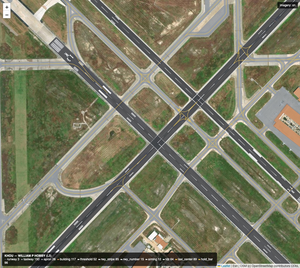
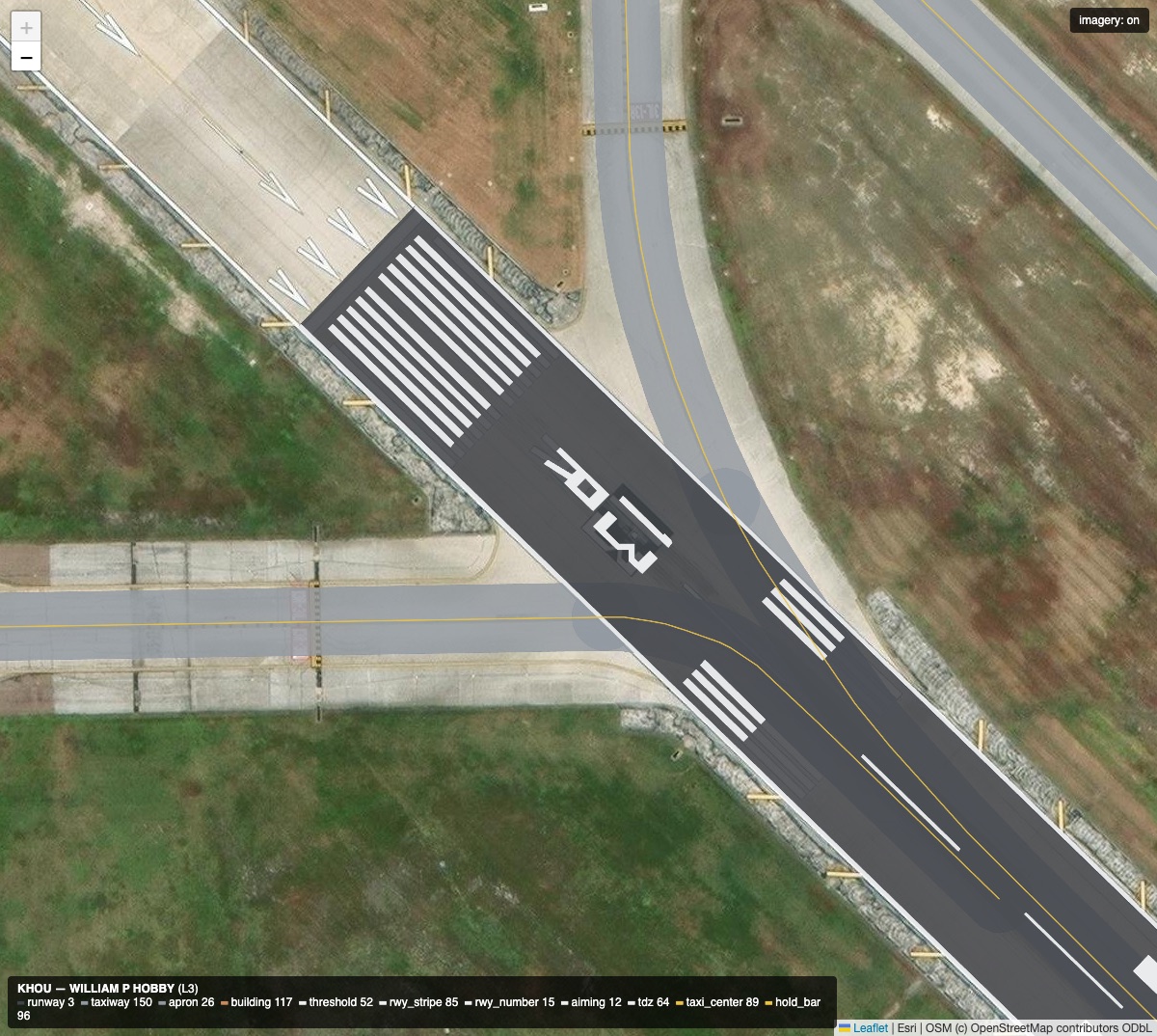
Airport diagrams should be more than flat pavement shapes. Our Level 3 layout work uses AI agents to turn raw airport geometry into richer operational diagrams: runway striping, threshold markings, aiming points, touchdown-zone markings, runway designator numbers, hold-short bars, taxiway centerlines, smarter pavement joins, and terrain patching that cleans up hill-shaded data so the airport surface reads beautifully.

  • Level 3 detail Runways gain the visual cues pilots actually use: threshold bars, centerline dashes, edge stripes, aiming points, touchdown-zone ladders, and precise runway numbers.
  • Taxiway geometry AI-driven surface enrichment improves taxiway layouts, centerlines, hold-short bars, apron joins, and connector fillets so the movement area behaves like a diagram, not just a map trace.
  • Agent enhancement Agents compare source geometry, airport context, and pavement relationships to add missing detail and correct weak joins while keeping the output deterministic and inspectable.
  • Terrain patching Terrain patches clean up hill-shaded elevation artifacts around the movement area, letting runways, taxiways, aprons, and surrounding terrain sit together cleanly in the map.
airport layouts / level 3 KHOU · William P. Hobby
Level 3 airport layout overlay at KHOU showing runway markings, taxiway centerlines, hold-short bars, and connector geometry
L3 diagram Runway numbers Taxiway fillets Hold-short bars AI enhanced
Level 3 layouts add runway paint, taxiway centerlines, hold-short logic, movement-area surfaces, and connector geometry on top of source airport data.
Close-up of AI enhanced runway threshold markings and runway designator numbers at KHOU
Runway marks + numbers
// Engines

Routing, wind, and navigation engines.

The visible AQ tools sit on reusable aviation engines that the interfaces and agents can call directly. Routing chooses viable paths and stops, wind turns forecast grids into flight math, and navigation keeps the whole system speaking in airports, fixes, airways, procedures, and geometry.

3 ENGINES
01 / Routing Rust graph

Routing

The routing engine runs a snapshot-backed Rust graph for direct, corridor, high-airway, low-airway, and SID/STAR-aware routes. It also ranks stop itineraries using aircraft range, runway, fuel, customs, handler, water, price, and wind constraints.

  • Snapshot router.bin starts a deterministic navigation graph quickly for web, CLI, and iOS surfaces.
  • Route modes DCT, DCT+, corridor, high/low airways, and procedure-aware paths can be compared from the same engine.
  • Stop logic Fuel, runway, customs, handlers, water policy, special-use filters, and wind-adjusted range shape each itinerary.
ModesDCT+ / Hi / Lo
PlannerStops + routes
OutputGeoJSON
Open Routes
02 / Wind GFS aloft

Wind

The wind engine parses NOAA GFS GRIB2 forecasts and samples routes through altitude, space, and time. It returns headwind, tailwind, groundspeed, ETE, route-average wind, temperature, ISA deviation, and per-segment values for planners and agents.

  • Forecasts Cycle-aware GFS downloads cover forecast hours out to 72 hours with pressure levels through FL515.
  • Interpolation Latitude, longitude, pressure, and time interpolation turn gridded weather into route-specific values.
  • Sampling Great-circle segments, 15 NM samples, and time-weighted averaging feed route and stop planning.
Window0-72H
CeilingFL515
Samples15 NM
Open Winds
03 / Navigation NASR graph

Navigation

The navigation engine turns FAA/NASR records into the graph language AQ uses: airports, fixes, VORs, NDBs, airways, filed route strings, and normalized route geometry. It lets tools and agents talk in aviation terms instead of raw coordinates.

  • Waypoints Airports, fixes, VORs, NDBs, and airway segment records become consistent navigation nodes.
  • Parser Filed routes can be parsed, expanded, normalized, and rendered back as route geometry.
  • Contracts Shared JSON schemas and GeoJSON outputs keep the web app, APIs, agents, and iOS clients aligned.
SourceNASR
NetworkAirways
OutputRoutes
Open Map
// What's inside

A look at the current tools.

Each one is purpose-built for a single slice of the planning workflow — a small, fast, sharp instrument. Click in to try any of them. Sign-in required where the tool needs account context.

11 TOOLS
AI Creates Smarter Procedures

Next Generation Procedures

Browse procedures drawn dynamically from FAA-derived source facts. Select feeder or IAF approach paths, resolve minima by aircraft category, and tilt the approach into 3D context.

05C · RNAV (GPS) RWY 08
PATHVia BOONE FIPEX
MINIMACat B · LPV / LNAV
VIEW2D 3D tilt
SOURCEFAA 1A1 facts
Browse Procedures
Better Airport Finding

Airport Finder

Browse 14,000+ airports on a map with runway data, weather category, handlers, and quick-jump planning. Filter by size, IFR, customs — pan and zoom to see what's around.

MAP + LIST · 14,389 IN VIEW
KAPA CentennialVFR
KBJC Rocky Mountain MetroVFR
KEIK Erie MuniMVFR
KCFO Colorado Air-ParkIFR
Browse Airports
Better Flight Planning

Planner

One-way and multi-stop trip planning with aircraft profiles, fuel math, runway minimums, and great-circle efficiency scoring. Pick your route from Flown / DCT / Hi / Lo options and see the segments break down leg-by-leg with ETD / ETA timing.

PLANNER · CJ3
One Way Multi-StopKSBA → KBZN · 789 NM
ROUTEFlown DCT · ⚡ 100%
CRUISE / FUELFL450 · 1,600 lbs
ETD → ETA09:00 → 11:03 local
Open Planner
Better Route Intelligence

Route Lookup

Cleared-as-filed routings between any two airports, drawn from millions of flown plans. Find the route ATC actually gives.

KSFO → KJFK · 12 ROUTES
FL370 · DCT MOD22% · 318x
FL390 · ALWYS J8018% · 261x
FL410 · NORCAL15% · 217x
FL350 · DCT BIL11% · 159x
Lookup Routes
Better Wind Planning

Winds Aloft

Average headwind, ground speed, and per-segment winds aloft for any route at your cruise. NOAA forecast, tuned to your airframe.

TNCM → KSBA · FL450 · 400 KTAS
AVG HDWD64 kt
WIND EFFECT+90 min
AVG GS336 kt
AVG WIND272° / 71 kt
Open Winds
Better Door-to-Door Planning

Door-to-Door Assistant

An end-to-end assistant for cross-country trips — drive to the FBO, brief, fly, button up, drive home. Drop in any origin and destination — addresses, cities, or codes — and we lay out a step-by-step timeline with suggested fuel stops, ground time, and arrival window.

DOOR-TO-DOOR · DC → NYC
FROM1600 Pennsylvania Ave NW
TO350 Fifth Ave, New York NY
DRIVE → BRIEF → FLY → DRIVE0:32 · 0:30 · 0:55 · 0:18
ETA14:42 local · 2h15 total
Open Door-to-Door Assistant
Better Customs Finding

Customs Finder

Find AOE / CBP airports along your route. Filter by hours, fees, FBO, weekend availability — every facility tagged at a glance.

39 FACILITIES IN VIEW · TNCM → KNEW
KAPF NAPLES MUNIUser Fee Wknd
KFLL FT LAUDERDALE INTLCAA 24/7
KEYW KEY WEST INTLUser Fee
KMCF MACDILL AFBUser Fee 24/7
Find Customs
Better Fuel Program Finding

CAA Finder

Avgas is up ~50% in the last few months. Cool. Finding more places to save with your CAA card matters more than ever — every CAA-participating handler in the playground, green-haloed on the map.

CAA-PARTICIPATING · 280 AIRPORTS
KABI ABILENE RGNLCAA
KAFK NEBRASKA CITYCAA
CYQB QUEBEC CITYCAA
CYVR VANCOUVER INTLCAA
Find CAA airports
Better Weather Context

METAR History

Last 24 hours of observations for any airport — raw text plus parsed wind / vis / ceiling / temp / altimeter, freshest first, with field-local time stamps. Reusable as a brick on any surface.

KDEN · LAST 24 HOURS
02:53Z 36 kt G50 · 5 SMMVFR
01:53Z 32 kt · 8 SMVFR
00:53Z 28 kt · 10 SMVFR
23:53Z 24 kt · 10 SMVFR
Open METAR history
Better Agent Connections

Disco MCP

Plug Aeronautic into LLM agents like Claude and ChatGPT via the Model Context Protocol. The agent gets live access to weather, NOTAMs, routes, customs, handlers — and can render Bricks inline as widgets, not just text.

MCP TOOLS · 150+ EXPOSED
airport_wx notamsweather + NOTAMs
flight_plan flight_routesrouting + stops
airport_customs airport_handlerscustoms + FBOs
claude chatgptadd as a connector
Connect to your agent
AI Creates What Comes Next

Want to see more?

If a tool here is missing, broken, or sparks an idea — tell us. The goal of the playground is to keep proving what AI can build for aviation, one small sharp utility at a time.

PITCH A TOOL · ASK FOR A FEATURE · REPORT A BUG
What's missing?Tell us
What's broken?Tell us
What would help?Tell us
Send a note
// Composable

Bricks — the building blocks every Aeronautic tool is made from.

Each tool above is composed from Bricks™ — small, self-contained UI cards (airport info, weather, route, stop options, runway diagrams) that we author once and reuse everywhere. The Planner, the Door-to-Door Assistant, the airport panel, the routes and winds tools — every surface is an arrangement of bricks rather than a hand-rolled page.

Bricks also render as standalone widgets you can embed on another site or open via /embed/<brick>, and we're experimenting with surfacing them inside AI hosts (Claude, ChatGPT) via MCP so an agent can drop a live runway diagram or route map directly into a reply. That side is still maturing — treat it as a sneak peek, not a daily-driver.

Open gallery
airport-info
core
From airport_info MCP tool · KASE
metar
core
From airport_metar · KASE
routes-between
planning
From flight_routes · KASE → KSGR
stop-options
planning
From flight_stops · KSBA → MRLB
// Request a feature

What would make this more useful for you?

Tell us what's missing — a brick, a tool, a data source, a workflow. Every request goes straight to our AI agents — they pick it up and start digging in.

// Dispatch

Disco — your AI dispatch co-pilot.

Disco™ is an experimental bridge that teaches AI teammates how to help your flight operation. Grok Bot is the host we prefer — a persistent teammate with its own computer that installs Disco and its skills directly. OpenClaw still works.

Inside Grok Bot, Disco rides shotgun on every leg — weather, NOTAMs, fuel stops, customs, handlers, route options — and answers in plain English. Ask "any reason not to take 13L into Houston tonight?" or "where should I tanker fuel for KSBA → MRLB?" and get a real operational read, sourced from live data.

Learn more about Disco disco.aeronautic.ai

PIC KSBA → MRLB tomorrow morning in the CJ3 with 4 pax. Anything I should know?
DISCO 1,830 nm, ~4h45 wheels-up to wheels-down. CJ3's range puts you one stop short — KHOU is the cheapest jet-A on the route ($5.21 contract). MRLB has a 200ft over Pacific approach; expect MVFR at arrival. Customs is fine — MRLB user-fee airport, 24h notice already on file. RAPT is quiet across SoCal departure. Want me to file?
PIC Yeah file it. Use the J29 routing.
DISCO Filing N123AB · KSBA SADDE6 SADDE J29 KHOU · CJ3/L · 16:00Z…
// what disco knows
  • Live METAR / TAF / PIREPs
  • NOTAMs + TFRs along the route
  • Fuel pricing & FBO contracts
  • Customs + handler hours
  • TMI programs (GS / GDP / RAPT)
  • Filed-route history (SWIM)
// works through
Grok Bot OpenClaw Grok Claude Code Codex
1
Pick your host
Grok Bot is the recommended host. OpenClaw still works if that’s already your setup.
2
Wire up Disco
Tell Grok Bot to read disco.aeronautic.ai/install.md — it installs Disco and the skill. No JSON wrangling.
3
Drop in your Dispatch key
Paste your ForeFlight Dispatch API key once. Disco picks up your fleet, crew, and trip plans automatically.
4
Start talking
Ask anything — route prep, weather read, customs prerequisites. Disco answers with live data and links back.
Get started disco.aeronautic.ai/go
// Pipeline

Fusion — the SWIM data engine under the hood.

Fusion™ is our scalable, ultra-fast processing, packaging, and syncing engine for FAA SWIM data. Using the Fusion SDK, any app or server can keep a local copy of highly compressed, well-structured SWIM data using novel delta-distribution technology — every change ships as a tiny patch, and any data set can recover from corruption or missing records on its own.

Fusion powers NOTAMs, flight + traffic data, D-ATIS, flight plan info, callsigns, aircraft data, and constraint elements. The same SDK lets any downstream tool — ours or yours — keep a local copy in sync.

Live status
fusion-tfm
live
From tfm_advisory · GDP / GS / RAPT / FCA
fusion-status
live
From /api/databases/versions · per-feed health
fusion-oooi
live
From oooi · Out / Off / On / In
fusion-flightplans
live
From sfdps_flightplan_window